
Updated for 2026 – trek route, permit rules, fees, safety tips & weather details reviewed
Start Your Himalayan Adventure with the Kedar Tal Trek Guide 2026
The Kedar Tal Trek Guide 2026 takes you on one of the most breathtaking journeys in the Garhwal Himalayas. Located near Gangotri in Uttarkashi district, Uttarakhand, Kedar Tal sits at an elevation of about 4,750 meters above sea level.
This crystal-clear glacial lake is fed by the melting snow of the Kedar Glacier and reflects the mighty Thalay Sagar and Bhrigupanth peaks, creating a view that feels almost unreal.
Unlike the crowded Himalayan trails, the Kedar Tal Trek offers solitude, raw mountain beauty, and a true sense of adventure. The trek begins from Gangotri, one of the Char Dhams, and passes through dense forests of birch and bhoj trees, rocky paths, and high-altitude meadows before revealing the shimmering turquoise lake.
It’s a challenging yet rewarding route for trekkers who love exploring lesser-known trails.
Historically, Kedar Tal is considered sacred by devotees of Lord Shiva, and many locals believe it to be one of the resting places of Lord Shiva’s army. Over time, it has become a dream destination for trekkers and photographers looking for an offbeat Himalayan experience.
In this detailed high-altitude trek near Gangotri, you’ll find complete information on the trek route, distance, best time, difficulty level, permits, and essential travel tips to plan your perfect adventure.
Enjoy the beauty of nature, think before you trash it.
प्रकृति की सुंदरता का आनंद लें, इसे कूड़ा करकट, नष्ट करने से पहले सोचें।

Kedar Tal Trek Overview
Looking for a quick summary before diving deep into the trek to Kedar Tal Here’s an easy-to-scan overview:
- Location: Gangotri, Uttarkashi District, Uttarakhand, India
- Region: Garhwal Himalayas
- Maximum Altitude: Around 4,750 meters (15,580 feet) above sea level
- Trek Distance: Approximately 17–18 km (one way) from Gangotri to Kedar Tal
- Trek Duration: 5 to 6 days (including acclimatization and return)
- Starting Point: Gangotri (3,100 m)
- Ending Point: Kedar Tal Lake
- Difficulty Level: Moderate to Difficult – steep ascents, rocky terrain, and narrow paths
- Best Time to Visit: May to June and September to mid-October
- Temperature Range:
- Day: 5°C to 15°C
- Night: -5°C to -10°C (at higher camps like Kedar Kharak and Kedar Tal)
- Nearest Town: Uttarkashi (about 100 km from Gangotri)
- Nearest Airport: Jolly Grant Airport, Dehradun (250 km)
- Nearest Railway Station: Dehradun (240 km)
- Permit Required: Yes – Gangotri National Park Entry Permit from Forest Department (Uttarkashi or Gangotri Check Post)
- Local Guide: Mandatory or strongly recommended for safety and navigation
- Trek Highlights:
- Stunning Kedar Tal (glacial lake) at 4,750 m
- Spectacular views of Thalay Sagar (6,904 m), Bhrigupanth, and Meru Peak
- Dense forests of bhojpatra and birch trees
- Scenic campsites at Bhoj Kharak and Kedar Kharak
- Crystal-clear reflections of snow peaks on Kedar Tal
- Accommodation Options: GMVN guest house, lodges, and homestays in Gangotri
- Mobile Network: Available only in Gangotri (BSNL and Jio work best)
- ATM Availability: Only in Uttarkashi and Harsil (no ATMs at Gangotri), mobile ATMs available during the peak tourist season
Kedar Tal Trek – Permit, Fees & Entry Rules
- The Kedar Tal Trek comes under the Gangotri National Park, a protected region managed by the Forest Department of Uttarkashi, Uttarakhand.
- A trekking permit is mandatory for all trekkers, guides, and porters entering the park area.
- The Gangotri National Park Entry Permit can be obtained from:
- The Forest Check Post near Gangotri Temple, or
- The Forest Department Office at Uttarkashi before leaving for Gangotri.
- Trekkers must carry a valid government photo ID (Aadhaar, Voter ID, or Passport) and submit a photocopy while applying for the permit.
- The permit is generally valid for a specific duration (as per the number of trekking days) and needs to be shown at forest check posts during the route.
- Hiring a local registered guide is mandatory or strongly recommended for safety and navigation, especially beyond Bhoj Kharak.
- The route passes through steep, rocky sections, and guides also help in coordinating with forest authorities and campsite arrangements.
- Permit Charges (latest available rates – subject to 2026 updates):
- Indian Trekkers: ₹150–200 per person per day
- Foreign Nationals: ₹600–800 per person per day
- Camera/Video Equipment: ₹250–500 (additional, if applicable)
- Fees may slightly vary depending on updated Gangotri National Park rules.
- Keep a soft copy and paper receipt of your permit throughout the trek for inspection.
- Entry inside the park is usually allowed only from May to mid-October, depending on weather and snow conditions.
Best Time to Visit Kedar Tal Trek
- The best time to visit Kedar Tal Trek is during the summer and autumn months — from May to June and September to mid-October.
- These months offer the most stable weather, clear skies, and comfortable trekking conditions to explore the high-altitude lake and surrounding peaks.
- The trek remains closed during winter (November to April) due to heavy snowfall and extreme cold in the Gangotri region.
- During the monsoon season (July and August), the trail becomes slippery and risky because of landslides and swollen streams, so it’s not recommended for trekking.
How to Reach Gangotri Dham – Starting Point of Kedar Tal Trek
By Air:
- The nearest airport is Jolly Grant Airport, Dehradun (about 270 km from Gangotri).
- Taxis and buses are easily available from the airport to Uttarkashi and further to Gangotri.
By Train:
- The nearest railway stations are Rishikesh (260 km) and Haridwar (280 km). From there, you can continue the journey by road.
By Road:
- Rishikesh = 260 km
- Haridwar = 280 km
- Dehradun = 250 km
- Delhi = 500 km
Gangotri Dham is well connected by motorable roads. Regular buses and taxis are available from Haridwar, Rishikesh, Dehradun, and Uttarkashi.
Travel Route (By Road):
Rishikesh / Haridwar / Dehradun → Narendra Nagar → Chamba → Dharasu Bend → Uttarkashi → Harsil → Gangotri
Safety Guide & Packing List for Kedar Tal Trek
Kedar Tal is a high-altitude adventure that rewards preparation. Here’s a simple safety and packing guide to help you stay ready for changing weather and tough mountain trails.
Safety Guide for Kedar Tal Trek
- The Kedar Tal Trek is a moderate to difficult high-altitude trek, reaching up to 4,750 meters, so proper fitness and preparation are essential.
- Always acclimatize well at Gangotri (1–2 days) before starting the trek to avoid altitude sickness.
- Hire a certified local guide from Gangotri — the trail has steep climbs, rocky terrain, and narrow ridges that require experienced navigation.
- Carry enough drinking water, ORS, and water purification tablets — water sources are limited after Kedar Kharak.
- Keep a personal medical kit with basic medicines, pain relievers, Diamox (for AMS prevention), and first-aid essentials.
- Avoid trekking alone; always stay with your group or guide, especially near rockfall and icy patches.
- Check weather updates at the Gangotri Forest Check Post before departure — conditions can change quickly in October.
- Carry proper winter gear if trekking in late September or October, as the temperature can drop below freezing at night.
- Respect local customs and avoid littering — Kedar Tal is considered sacred by devotees of Lord Shiva.
- Carry back all non-biodegradable waste to Gangotri; plastic use is strictly prohibited inside Gangotri National Park.
In recent years, forest authorities have increased checks on group size, waste management, and guide registration, so trekkers are advised to strictly follow updated 2026 rules.
Essential Packing List for Kedar Tal Trek
Clothing & Gear
- 2–3 pairs of quick-dry trekking pants
- 3–4 full-sleeve thermal or fleece T-shirts
- 1 down jacket or heavy warm jacket (-10°C rating for October treks)
- 1 fleece or woollen layer for insulation
- Waterproof and windproof outer shell jacket
- Thermal innerwear (top & bottom)
- Woollen cap, balaclava, and gloves (waterproof + warm pair)
- Sunglasses (UV-protected, glacier-safe)
- Woollen socks (2 pairs) + cotton socks (2 pairs)
- Waterproof trekking shoes with good grip
- Gaiters (optional, for snow/loose gravel)
- Rain poncho or raincoat (for sudden showers)
Accessories & Equipment
- Trekking pole (essential for steep ascents)
- Lightweight backpack (50–60 L) + rain cover
- Sleeping bag (good for -10°C, if camping)
- Reusable water bottle or hydration bladder
- Headlamp or torch with extra batteries
- Sunscreen (SPF 50+), lip balm, and moisturizer
- Small towel, wet wipes, and biodegradable soap
- Power bank and camera with extra batteries
Personal Essentials
- Valid photo ID and trekking permits
- Personal medical kit (bandages, painkillers, Diamox, antiseptic)
- Energy bars, dry fruits, chocolates for quick energy
- Reusable garbage bag (for carrying waste)
Pro Tips
- Train your body 3–4 weeks before the trek — focus on cardio, leg strength, and endurance.
- Stay hydrated and ascend gradually to avoid AMS (Altitude Mountain Sickness).
- Do not skip acclimatization — spend at least one night at Gangotri before starting.
- Avoid alcohol and smoking during the trek; they increase dehydration risk.
- Always follow your guide’s instructions and respect mountain safety rules.
Quick Facts for Trekkers
| Detail | Information |
| Trek Start Point | Gangotri, Uttarkashi |
| End Point | Kedar Tal Lake |
| Total Distance | ~34 km (to & fro) |
| Duration | 5–6 days |
| Highest Altitude | 4,750 m |
| Difficulty Level | Moderate to Difficult |
| Best Time | May–June & Sept–mid Oct |
| Permit Required | Yes, from Forest Department (Gangotri) |
Day-by-Day Kedar Tal Trek Route Plan
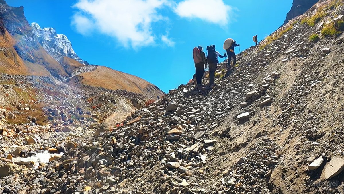
The Kedar Tal Trek route starts from Gangotri (3,048 m) in Uttarkashi district, Uttarakhand — the same sacred town that serves as the base for the Gaumukh–Tapovan trek. The entire route takes you deep into the Gangotri National Park, leading through pine and birch forests, steep rocky climbs, and stunning views of Thalay Sagar (6,904 m) and Bhrigupanth (6,772 m) peaks.
Route Path:
Dehradun / Haridwar/ Rishikesh → Uttarkashi → Gangotri → Bhoj Kharak → Kedar Kharak → Kedar Tal Lake
- Total Distance: ~34 km (round trip)
- Trek Gradient: Moderate to Difficult (suitable for experienced trekkers)
- Trail Type: Forest trails, rocky climbs, moraine, and steep ascents
- Network Availability: Intermittent till Gangotri; no signal beyond Bhoj Kharak
- Water Source: Streams available up to Kedar Kharak; carry enough water thereafter
Day 1: Arrival at Gangotri Dham (3,048 m)/ गंगोत्री धाम

- Reach Gangotri via Uttarkashi.
- Complete forest entry formalities and take rest for acclimatization.
- Explore the Gangotri Temple and enjoy views of the Bhagirathi River.
Day 2: Gangotri to Bhoj Kharak (8 km, 5–6 hrs)/ गंगोत्री से भोज खरक

- The trek begins with a moderate climb through deodar and birch forests.
- Cross small streams and enjoy early views of Thalay Sagar.
- Camp at Bhoj Kharak (3,780 m) — a beautiful campsite surrounded by cliffs and trees.
Day 3: Bhoj Kharak to Kedar Kharak (4 km, 3–4 hrs)/ भोज खरक से केदार खरक

- A short but steep trail, with some rocky sections and landslide zones.
- The path opens into a meadow near Kedar Kharak (4,280 m) with stunning views of Bhrigupanth Peak.
- Ideal place for photography and acclimatization.
Day 4: Kedar Kharak to Kedar Tal (5 km, 4–5 hrs)/ केदार खरक से केदार ताल

- The most challenging day of the trek.
- Steep ascent over loose rocks and moraine, requiring careful footing.
- Finally reach the emerald-blue Kedar Tal Lake, reflecting Thalay Sagar and Bhrigupanth peaks.
- Spend time exploring the surroundings before descending back to Kedar Kharak or camping near the lake (depending on weather).
Day 5: Return Trek to Gangotri (12–13 km, 6–7 hrs)/ गंगोत्री वापसी
- Descend via the same route through Kedar Kharak and Bhoj Kharak to reach Gangotri.
- Trek ends with a scenic walk through the forest and river valley.
Food & Water Availability on Kedar Tal Trek
The Kedar Tal Trek is a remote high-altitude trail with limited facilities beyond Gangotri, so trekkers should plan their food and water arrangements carefully. Here’s everything you need to know before heading out:
Food Availability
- At Gangotri: You’ll find plenty of dhaba-style restaurants, small cafes, and guesthouses serving hot meals like rice, dal, roti, and vegetables. Local food stalls also offer tea, snacks, and packed lunch options.
- During the Trek: Once you leave Gangotri, there are no permanent food stalls or shops on the route.
- If trekking with a registered guide or local trekking agency, meals are usually prepared by the staff at campsites.
- Solo trekkers must carry ready-to-eat food, instant noodles, energy bars, dry fruits, and snack items for the entire trek.
- Cooking fuel or gas stoves are essential if you plan to prepare meals yourself, as firewood collection is prohibited inside the Gangotri National Park.
Water Availability
- Freshwater sources like streams and small rivulets are available till Kedar Kharak.
- After that, water sources are scarce, so it’s important to refill bottles before starting the final climb to Kedar Tal.
- Always carry at least 2 liters of water per person and use water purification tablets or filters before drinking.
- In colder months, you can melt snow near higher camps if needed.
Quick Tips
- Carry lightweight cooking gear or camping stoves if trekking independently.
- Avoid plastic bottles and litter; use reusable water bottles.
- Refill from clean, flowing streams — never stagnant water.
- Keep some ORS packets or electrolyte drinks to prevent dehydration at high altitude.
Accommodation Options on Kedar Tal Trek
Accommodation on the Kedar Tal Trek is basic and limited, especially after you leave Gangotri. Trekkers should be prepared for camping stays or simple lodges depending on the location. Here’s a full breakdown of where and how you can stay during the trek:
Stay at Gangotri (Base Point)
- Gangotri offers a range of lodges, guesthouses, and GMVN (Garhwal Mandal Vikas Nigam) rest houses for trekkers and pilgrims.
- You’ll find budget hotels, ashrams, and homestays with basic rooms and meals available.
- Advance booking is recommended during the Char Dham Yatra season (May–June).
- Some popular options include:
- GMVN Tourist Rest House
- Gangotri Dham Cottages
Pro Tip: Stay at least one night in Gangotri for acclimatization before starting the trek.
Camping at Bhoj Kharak (3,780 m)
- Bhoj Kharak is the first campsite, located about 8 km from Gangotri.
- It’s a small patch of open ground surrounded by birch trees and rocky cliffs.
- Trekkers generally set up tents here with the help of guides or local porters.
- No tea shops or dhabas — you’ll need to carry food, camping gear, and cooking supplies.
Camping at Kedar Kharak (4,280 m)
- Kedar Kharak is one of the most beautiful campsites in the Gangotri region, with clear views of Thalay Sagar and Bhrigupanth peaks.
- There are flat meadows perfect for pitching tents.
- You can find natural water sources nearby, making it ideal for a night halt.
- The area gets windy and cold at night, so pack warm sleeping bags.
Camping Near Kedar Tal Lake (Optional)
- Camping near the lake (4,750 m) is allowed only when weather permits and with special permission from the Forest Department.
- Strong winds and rocky terrain make camping challenging here.
- Most trekkers prefer returning to Kedar Kharak the same day after exploring the lake.
Accommodation Type Summary
| Location | Type | Facilities | Notes |
| Gangotri | Lodges, GMVN, Guesthouses | Meals, power, hot water (limited) | Best for acclimatization |
| Bhoj Kharak | Camping only | Water source nearby | Basic campsite |
| Kedar Kharak | Camping only | Scenic view, clean water | Ideal overnight halt |
| Kedar Tal Lake | Limited camping | Only with permission | Very cold & windy |
Tips for Trekkers
- Carry your own tent and sleeping bag, or hire from Gangotri or Uttarkashi.
- Always check weather updates before setting up camp at higher altitudes.
- Leave no waste behind — practice eco-friendly trekking.
- If trekking solo, consider hiring a local guide who can help with camping and setup.
Conclusion: Kedar Tal Trek Guide 2026
The trek to Kedar Tal lake is not just about reaching a high-altitude lake; it’s about experiencing the untouched beauty and spiritual calm of the Himalayas. From the holy town of Gangotri to the crystal-blue waters of Kedar Tal, every step on this trek feels like a journey through nature’s raw and powerful landscapes.
Standing at the lake, with the mighty Thalay Sagar Peak rising before you, gives a deep sense of peace and achievement that few places can match. Whether you’re an experienced trekker or an adventure seeker looking for something new, this trek offers both challenge and serenity in equal measure.
Plan your journey smartly, follow safety guidelines, and respect the environment — the Kedar Tal Trek 2026 will reward you with unforgettable views, calm solitude, and the true essence of Himalayan adventure.
FAQs – Kedar Tal Trek Guide 2026
What is the total distance of the Kedar Tal Trek?
The Kedar Tal Trek distance is around 34 km (to and fro) from Gangotri. It usually takes 5 to 6 days to complete, depending on weather and fitness level.
Where does the Kedar Tal Trek start from?
The Kedar Tal Trek starts from Gangotri town in Uttarkashi district, Uttarakhand. Gangotri is also the base point for the famous Gaumukh–Tapovan trek.
Is Kedar Tal Trek open in 2026?
Yes, the Kedar Tal Trek is open from May–June and September–mid October 2026, subject to weather and Gangotri National Park permissions.
What is the best time to visit Kedar Tal Trek in 2026?
The best time for Kedar Tal Trek 2026 is from May to June and September to mid-October. During these months, the weather is stable and the trail is clear for trekking.
Is a permit required for Kedar Tal Trek?
Yes, trekkers must obtain a permit from the Forest Department at Gangotri since the trail passes through Gangotri National Park. Carry valid ID proof and pay the entry and camping fees.
How difficult is the Kedar Tal Trek?
The Kedar Tal Trek is considered moderate to difficult. It involves steep climbs, rocky paths, and high-altitude sections up to 4,750 meters. Prior trekking experience or good fitness is recommended.
Can beginners do the Kedar Tal Trek?
While beginners can attempt the trek with a certified local guide, it’s better suited for trekkers who have some experience in high-altitude hiking.
What is the altitude of Kedar Tal Lake?
Kedar Tal Lake is located at an altitude of around 4,750 meters (15,584 feet) above sea level, surrounded by Thalay Sagar and Bhrigupanth peaks.
How to reach Kedar Tal Trek from Delhi or Dehradun?
To reach the Kedar Tal Trek, first travel to Uttarkashi and then to Gangotri by road.
- Nearest Airport: Jolly Grant Airport, Dehradun (270 km)
- Nearest Railway Station: Rishikesh (260 km), Haridwar (280 km), Dehradun (250 km)
- Road Route: Delhi → Dehradun → Uttarkashi → Gangotri
Are there accommodation options during the Kedar Tal Trek?
Yes. Trekkers can stay in guesthouses and GMVN rest houses in Gangotri and camp at Bhoj Kharak, Kedar Kharak, and near Kedar Tal (with permission).
What kind of food is available on the Kedar Tal Trek?
Hot meals are available in Gangotri, but there are no food stalls beyond it. Trekkers should carry ready-to-eat food, snacks, and dry fruits, or cook meals at campsites.
How is the mobile network on the Kedar Tal Trek route?
Mobile network connectivity is available only up to Gangotri. There is no signal beyond Bhoj Kharak, so inform family or friends before starting the trek.
Is camping allowed at Kedar Tal Lake?
Camping at Kedar Tal Lake is allowed only in good weather and with special permission from the Forest Department. Most trekkers camp at Kedar Kharak instead.
What should I pack for Kedar Tal Trek 2026?
Carry warm clothing, trekking shoes, rain cover, sleeping bag, water purifier, energy snacks, and a first-aid kit. A full Kedar Tal Trek packing list is shared in the safety guide section above.
Can I do the Kedar Tal Trek solo?
Solo trekking is allowed but not advised due to steep climbs, tricky terrain, and wildlife presence. It’s safer to go with a registered guide or trekking group.
Why is Kedar Tal famous?
Kedar Tal is known for its crystal-clear glacial lake, which reflects the mighty Thalay Sagar Peak. It’s one of the most scenic high-altitude treks near Gangotri, combining spirituality, adventure, and Himalayan beauty.
3 thoughts on “Kedar Tal Trek Guide (2026): Route, Distance, Permit, Best Time & Safety Tips | केदारताल ट्रेक”
Comments are closed.